Geolocate

Wellington topographic map

Click on the map to display elevation.

About this map

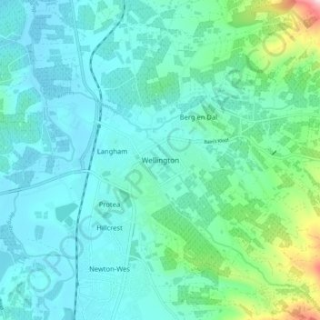
Name: Wellington topographic map, elevation, terrain.

Location: Wellington, Drakenstein Local Municipality, Cape Winelands District Municipality, Western Cape, 7655, South Africa (-33.68306 18.97056 -33.60306 19.05056)

Average elevation: 551 ft

Minimum elevation: 269 ft

Maximum elevation: 1,946 ft

Other topographic maps

Click on a map to view its topography, its elevation and its terrain.

Gear up for your next adventure:

GPS Sports Watch - GPS watch for running, hiking and training
📦Gear Storage Bags - Organize and protect outdoor equipment
🔋Rechargeable Batteries - Power up your outdoor devices
🌲Outdoor Survival Books - Best books on survival skills
☀️Outdoor Sunscreen - High protection sunscreen for outdoor activities

As an Amazon Associate, this site earns from qualifying purchases at no extra cost to you.