
Make a donation
Gear up for your next adventure:
As an Amazon Associate, this site earns from qualifying purchases at no extra cost to you.
Putbus topographic map
Click on the map to display elevation.
Make a donation
Gear up for your next adventure:
As an Amazon Associate, this site earns from qualifying purchases at no extra cost to you.
Putbus
Die Flagge der Stadt Putbus ist gleichmäßig längsgestreift von Schwarz und Gold (Gelb). In der Mitte des Flaggentuchs liegt, auf jeweils zwei Drittel der Höhe des schwarzen und des goldenen (gelben) Streifens übergreifend, das Stadtwappen. Die Länge des Flaggentuchs verhält sich zur Höhe wie 5:3.
Make a donation
Gear up for your next adventure:
As an Amazon Associate, this site earns from qualifying purchases at no extra cost to you.
About this map
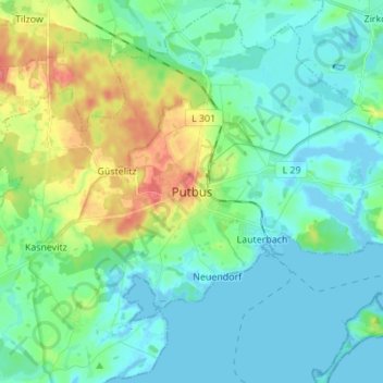
Name: Putbus topographic map, elevation, terrain.
Average elevation: 52 ft
Minimum elevation: -10 ft
Maximum elevation: 203 ft
Make a donation
Gear up for your next adventure:
As an Amazon Associate, this site earns from qualifying purchases at no extra cost to you.