Geolocate

Kiwatule topographic map

Click on the map to display elevation.

About this map

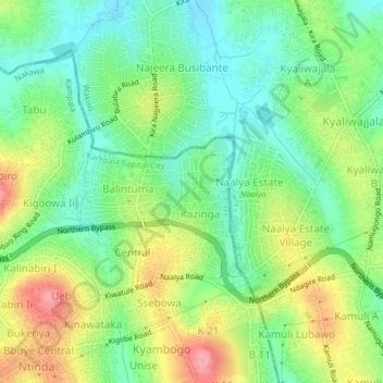
Name: Kiwatule topographic map, elevation, terrain.

Location: Kiwatule, Kampala, Central Region, Uganda (0.35274 32.60986 0.39274 32.64986)

Average elevation: 3,891 ft

Minimum elevation: 3,747 ft

Maximum elevation: 4,121 ft

Other topographic maps

Click on a map to view its topography, its elevation and its terrain.

Makindye

Uganda > Central Region > Kampala

Average elevation: 3,871 ft

Nalukolongo (zone)

Uganda > Central Region > Kampala

Average elevation: 3,894 ft

Makindye

Uganda > Central Region > Kampala

Average elevation: 3,871 ft

Central

Uganda > Central Region > Kampala

Average elevation: 3,914 ft

Central

Uganda > Central Region > Kampala

Average elevation: 3,914 ft

Central

Uganda > Central Region > Kampala

Average elevation: 3,914 ft

Wansanso (zone)

Uganda > Central Region > Kampala

Average elevation: 3,878 ft

Bahai

Uganda > Central Region > Kampala

Average elevation: 3,937 ft

Gear up for your next adventure:

🩹Survival Bandages - High‑quality bandages for emergencies
👟Men's Trail Runners - Lightweight footwear for fast-paced exploration and light hiking
🎒Day Hiking Backpack - Lightweight backpack perfect for day trips and outdoor adventures
👖Convertible Hiking Pants - Versatile zip-off pants for changing altitudes and temperatures
🎁Geography Themed Gifts - Unique gift ideas for map lovers and geography enthusiasts

As an Amazon Associate, this site earns from qualifying purchases at no extra cost to you.