Geolocate

Ranomut topographic map

Click on the map to display elevation.

About this map

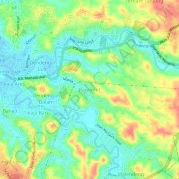
Name: Ranomut topographic map, elevation, terrain.

Location: Ranomut, Manado, North Sulawesi, Sulawesi, 95129, Indonesia (1.46428 124.84844 1.50428 124.88844)

Average elevation: 105 ft

Minimum elevation: 23 ft

Maximum elevation: 226 ft

Gear up for your next adventure:

🌲Outdoor Survival Books - Best books on survival skills
🎁Geography Themed Gifts - Unique gift ideas for map lovers and geography enthusiasts
🥄Camping Utensil Set - Lightweight utensils for outdoor meals
🪄Magnetic Compass - Accurate compass for navigation
🪑Portable Camp Table - Compact table for campsite meals

As an Amazon Associate, this site earns from qualifying purchases at no extra cost to you.