
Make a donation
Gear up for your next adventure:
As an Amazon Associate, this site earns from qualifying purchases at no extra cost to you.
Taco Pozo topographic map
Click on the map to display elevation.
Make a donation
Gear up for your next adventure:
As an Amazon Associate, this site earns from qualifying purchases at no extra cost to you.
About this map
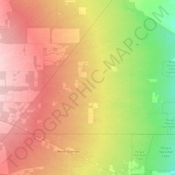
Name: Taco Pozo topographic map, elevation, terrain.
Location: Taco Pozo, Almirante Brown, Chaco, 3717, Argentina (-25.65503 -63.42247 -24.83195 -61.71181)
Average elevation: 863 ft
Minimum elevation: 627 ft
Maximum elevation: 1,444 ft
Make a donation
Gear up for your next adventure:
As an Amazon Associate, this site earns from qualifying purchases at no extra cost to you.
Other topographic maps
Click on a map to view its topography, its elevation and its terrain.
Make a donation
Gear up for your next adventure:
As an Amazon Associate, this site earns from qualifying purchases at no extra cost to you.
Plaza de la Integración Aldo y Efraín Boglietti
Argentina > Chaco > Resistencia
Average elevation: 174 ft
Make a donation
Gear up for your next adventure:
As an Amazon Associate, this site earns from qualifying purchases at no extra cost to you.