
Make a donation
Gear up for your next adventure:
As an Amazon Associate, this site earns from qualifying purchases at no extra cost to you.
Mambajao topographic map
Click on the map to display elevation.
Make a donation
Gear up for your next adventure:
As an Amazon Associate, this site earns from qualifying purchases at no extra cost to you.
About this map
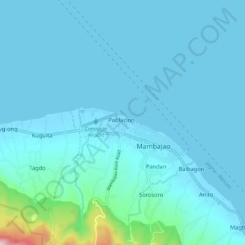
Name: Mambajao topographic map, elevation, terrain.
Location: Mambajao, Camiguin, Northern Mindanao, 9100, Philippines (9.20569 124.68694 9.28569 124.76694)
Average elevation: 259 ft
Minimum elevation: -3 ft
Maximum elevation: 2,260 ft
Make a donation
Gear up for your next adventure:
As an Amazon Associate, this site earns from qualifying purchases at no extra cost to you.
Other topographic maps
Click on a map to view its topography, its elevation and its terrain.
Camiguin
Philippines > Camiguin > Mambajao
Camiguin Island is a pearl-shaped island with an area of approximately 238 square kilometers (92 sq mi). The island measures about 23 kilometers (14 mi) at its longest and 14.5 kilometers (9.0 mi) at its widest breadth. The island is mountainous with the highest elevation reaching over 5,000 ft (1,500 m). It…
Average elevation: 679 ft