
Mostacciano topographic map
Click on the map to display elevation.
About this map
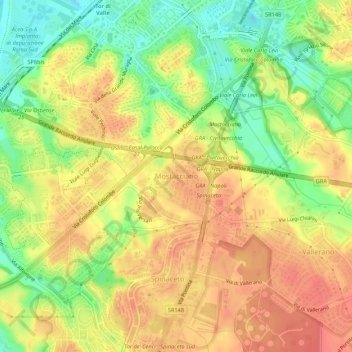
Name: Mostacciano topographic map, elevation, terrain.
Location: Mostacciano, Rome, Roma Capitale, Lazio, 00128, Italy (41.77934 12.42798 41.81934 12.46798)
Average elevation: 131 ft
Minimum elevation: 13 ft
Maximum elevation: 217 ft
Other topographic maps
Click on a map to view its topography, its elevation and its terrain.
Parco degli Acquedotti
Italy > Lazio > Roma Capitale > Rome > Osteria del Curato
Average elevation: 203 ft