Geolocate

Red House topographic map

Click on the map to display elevation.

About this map

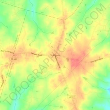
Name: Red House topographic map, elevation, terrain.

Location: Red House, Charlotte County, Virginia, 23963, United States (37.16913 -78.83196 37.20913 -78.79196)

Average elevation: 705 ft

Minimum elevation: 581 ft

Maximum elevation: 794 ft

Charlotte County trails, hiking, mountain biking, running and outdoor activities

Other topographic maps

Click on a map to view its topography, its elevation and its terrain.

Keysville

United States > Virginia > Charlotte County

Average elevation: 614 ft

Phenix

United States > Virginia > Charlotte County

Average elevation: 436 ft

Drakes Branch

United States > Virginia > Charlotte County

Average elevation: 443 ft

Gear up for your next adventure:

GPS Sports Watch - GPS watch for running, hiking and training
🪶Wildlife Field Guides - Learn animal tracking and species ID
👖Convertible Hiking Pants - Versatile zip-off pants for changing altitudes and temperatures
🧭GPS Watch Accessories - Bands and chargers for GPS watches
🪶LED Camping Lantern - Bright lantern for camp lighting

As an Amazon Associate, this site earns from qualifying purchases at no extra cost to you.