Geolocate

Gothicville topographic map

Click on the map to display elevation.

About this map

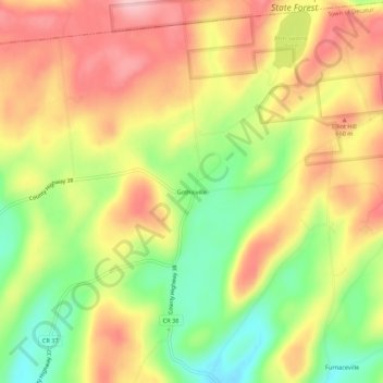
Name: Gothicville topographic map, elevation, terrain.

Location: Gothicville, Town of Decatur, Otsego County, New York, United States (42.65313 -74.71320 42.69313 -74.67320)

Average elevation: 2,018 ft

Minimum elevation: 1,719 ft

Maximum elevation: 2,280 ft

Otsego County trails, hiking, mountain biking, running and outdoor activities

Other topographic maps

Click on a map to view its topography, its elevation and its terrain.

Town of Middlefield

United States > New York > Otsego County

Average elevation: 1,647 ft

Village of Otego

United States > New York > Otsego County

Average elevation: 1,194 ft

Town of Oneonta

United States > New York > Otsego County

Average elevation: 1,496 ft

Town of New Lisbon

United States > New York > Otsego County

Average elevation: 1,558 ft

Town of Maryland

United States > New York > Otsego County

Average elevation: 1,608 ft

Town of Burlington

United States > New York > Otsego County

Average elevation: 1,634 ft

Village of Unadilla

United States > New York > Otsego County

Average elevation: 1,178 ft

Village of Morris

United States > New York > Otsego County

Average elevation: 1,240 ft

Springfield Center

United States > New York > Otsego County

Average elevation: 1,407 ft

City of Oneonta

United States > New York > Otsego County

Average elevation: 1,421 ft

City of Oneonta

United States > New York > Otsego County

Average elevation: 1,421 ft

Town of Worcester

United States > New York > Otsego County

Average elevation: 1,814 ft

Town of Worcester

United States > New York > Otsego County

Average elevation: 1,814 ft

Town of Hartwick

United States > New York > Otsego County

Average elevation: 1,604 ft

Town of Otego

United States > New York > Otsego County

Average elevation: 1,486 ft

Town of Butternuts

United States > New York > Otsego County

Average elevation: 1,450 ft

Town of Hartwick

United States > New York > Otsego County

Average elevation: 1,604 ft

City of Oneonta

United States > New York > Otsego County

Average elevation: 1,421 ft

Town of Maryland

United States > New York > Otsego County

Average elevation: 1,608 ft

Gear up for your next adventure:

📖Nature Tracking Books - Learn to track wildlife and terrain
🎒Trekking Poles - Sturdy poles for balance and stability on rough terrain
🛡️Insect Repellent - Protection against bugs during outdoor activities
🔥Camping Stove - Portable stove for camping and backcountry cooking
🌐World Map Poster - Decorative world maps with topographic info

As an Amazon Associate, this site earns from qualifying purchases at no extra cost to you.