
Make a donation
Gear up for your next adventure:
As an Amazon Associate, this site earns from qualifying purchases at no extra cost to you.
Nieuwkerke topographic map
Click on the map to display elevation.
Make a donation
Gear up for your next adventure:
As an Amazon Associate, this site earns from qualifying purchases at no extra cost to you.
Nieuwkerke
Nieuwkerke ligt in Zandlemig Vlaanderen en in het West-Vlaams Heuvelland op een hoogte van ongeveer 65 meter. Hier ligt de zuidelijke heuvelkam van het heuvelland met De Walletjes en Zwarte Molen (80 meter). Ten noorden van Nieuwkerke loopt de Douvebeek in oostelijke richting. Naar het zuiden toe neemt de hoogte snel af, tot ongeveer 20 meter aan de Belgisch-Franse grens. Hier wordt de vallei van de Leie genaderd.
Make a donation
Gear up for your next adventure:
As an Amazon Associate, this site earns from qualifying purchases at no extra cost to you.
About this map
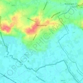
Name: Nieuwkerke topographic map, elevation, terrain.
Location: Nieuwkerke, Heuvelland, Ieper, West-Vlaanderen, 8950, België (50.70828 2.78894 50.76219 2.86962)
Average elevation: 98 ft
Minimum elevation: 46 ft
Maximum elevation: 259 ft
Make a donation
Gear up for your next adventure:
As an Amazon Associate, this site earns from qualifying purchases at no extra cost to you.
Other topographic maps
Click on a map to view its topography, its elevation and its terrain.
Make a donation
Gear up for your next adventure:
As an Amazon Associate, this site earns from qualifying purchases at no extra cost to you.