
Chengguan District topographic map
Interactive map
Click on the map to display elevation.
About this map
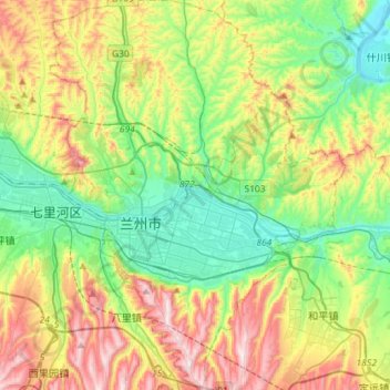
Name: Chengguan District topographic map, elevation, terrain.
Location: Chengguan District, Lanzhou, Gansu, China (35.96194 103.77697 36.15976 103.98278)
Average elevation: 5,673 ft
Minimum elevation: 4,856 ft
Maximum elevation: 7,113 ft
Other topographic maps
Click on a map to view its topography, its elevation and its terrain.
Hezuo
China > Gansu > Hezuo City
Hezuo, Hezuo City, Gannan, Gansu, 747000, China
Average elevation: 10,495 ft
Yellow River
China > Gansu > Maqu County > Gaoyuan Institute of Biology
Yellow River, Gaoyuan Institute of Biology, Maqu County, Gannan, Gansu, China
Average elevation: 11,499 ft
Zhangye Danxia National Geological Park
Zhangye Danxia National Geological Park, Nantai, Linze County, Zhangye, Gansu, 734200, China
Average elevation: 5,771 ft
Zhagana
China > Gansu > Têwo County > Zhagana
Zhagana, Têwo County, Gannan Tibetan Autonomous Prefecture, Gansu, China
Average elevation: 10,748 ft
Ning County
China > Gansu > Ning County
Ning County, Qingyang City, Gansu, China
Average elevation: 4,098 ft
Yanchuan
China > Gansu > Niangniangba > Yanchuan
Yanchuan, Niangniangba, Qinzhou District, Tianshui, Gansu, China
Average elevation: 5,922 ft
Asai
China > Gansu > Têwo County
Asai, Têwo County, Gannan Tibetan Autonomous Prefecture, Gansu, China
Average elevation: 8,012 ft
Gannan Tibetan Autonomous Prefecture
Gannan Tibetan Autonomous Prefecture, Gansu, 746300, China
Average elevation: 10,794 ft