
Make a donation
Gear up for your next adventure:
As an Amazon Associate, this site earns from qualifying purchases at no extra cost to you.
Zhangye topographic map
Click on the map to display elevation.
Make a donation
Gear up for your next adventure:
As an Amazon Associate, this site earns from qualifying purchases at no extra cost to you.
About this map
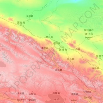
Name: Zhangye topographic map, elevation, terrain.
Location: Zhangye, Gansu, China (37.62649 97.39345 39.88689 102.20450)
Average elevation: 8,724 ft
Minimum elevation: 3,369 ft
Maximum elevation: 18,678 ft
Make a donation
Gear up for your next adventure:
As an Amazon Associate, this site earns from qualifying purchases at no extra cost to you.
Other topographic maps
Click on a map to view its topography, its elevation and its terrain.
Hezuo
China > Gansu > Hezuo City
With an elevation of nearly 3,000 metres (9,800 ft), Hezuo has an alpine subarctic climate (Köppen Dwc), with long, very cold, dry winters, and short, mild summers. The monthly daily mean temperature in January, the coldest month, is −9.3 °C (15.3 °F), while the same figure for July, the warmest month, is…
Average elevation: 10,495 ft
Make a donation
Gear up for your next adventure:
As an Amazon Associate, this site earns from qualifying purchases at no extra cost to you.