
Fragoselo topographic map
Interactive map
Click on the map to display elevation.
About this map
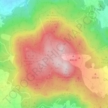
Name: Fragoselo topographic map, elevation, terrain.
Location: Fragoselo, Vigo, Pontevedra, Galicia, 36330, España (42.16038 -8.78851 42.18038 -8.76851)
Average elevation: 843 ft
Minimum elevation: 108 ft
Maximum elevation: 1,440 ft
Other topographic maps
Click on a map to view its topography, its elevation and its terrain.