
Make a donation
Gear up for your next adventure:
As an Amazon Associate, this site earns from qualifying purchases at no extra cost to you.
Küntrop topographic map
Click on the map to display elevation.
Make a donation
Gear up for your next adventure:
As an Amazon Associate, this site earns from qualifying purchases at no extra cost to you.
Küntrop
Der Ort liegt im Sauerland etwa zwei Kilometer östlich der Kleinstadt Neuenrade im Märkischen Kreis. Die Höhe des Ortes liegt bei etwa 285 m ü. NHN im Tal der hier noch jungen Hönne und steigt bis auf 499 m am Küntroper Berg an. Zur Etymologie von -trop siehe hier.
Make a donation
Gear up for your next adventure:
As an Amazon Associate, this site earns from qualifying purchases at no extra cost to you.
About this map
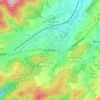
Name: Küntrop topographic map, elevation, terrain.
Average elevation: 1,119 ft
Minimum elevation: 830 ft
Maximum elevation: 1,657 ft
Make a donation
Gear up for your next adventure:
As an Amazon Associate, this site earns from qualifying purchases at no extra cost to you.