
Make a donation
Gear up for your next adventure:
As an Amazon Associate, this site earns from qualifying purchases at no extra cost to you.
Klein-Sinaai topographic map
Click on the map to display elevation.
Make a donation
Gear up for your next adventure:
As an Amazon Associate, this site earns from qualifying purchases at no extra cost to you.
Klein-Sinaai
Klein-Sinaai ligt in Zandig Vlaanderen en in het Waasland. De Moervaart en de Stekense Vaart zijn de belangrijkste waterlopen nabij Klein-Sinaai. In het noorden vindt men het Wullebos waarin ook het Baggaarthof ligt. De hoogte bedraagt ongeveer 5 meter.
Make a donation
Gear up for your next adventure:
As an Amazon Associate, this site earns from qualifying purchases at no extra cost to you.
About this map
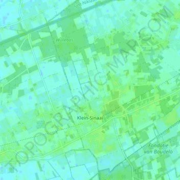
Name: Klein-Sinaai topographic map, elevation, terrain.
Average elevation: 13 ft
Minimum elevation: -3 ft
Maximum elevation: 26 ft
Make a donation
Gear up for your next adventure:
As an Amazon Associate, this site earns from qualifying purchases at no extra cost to you.
Other topographic maps
Click on a map to view its topography, its elevation and its terrain.
Make a donation
Gear up for your next adventure:
As an Amazon Associate, this site earns from qualifying purchases at no extra cost to you.