
Thank you for supporting this site ❤️
Make a donation
Make a donation
Gear up for your next adventure:
As an Amazon Associate, this site earns from qualifying purchases at no extra cost to you.
Nerja topographic map
Click on the map to display elevation.
Thank you for supporting this site ❤️
Make a donation
Make a donation
Gear up for your next adventure:
As an Amazon Associate, this site earns from qualifying purchases at no extra cost to you.
About this map
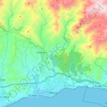
Name: Nerja topographic map, elevation, terrain.
Location: Nerja, La Axarquía, Malaga, Andalusia, Spain (36.73756 -3.91351 36.84184 -3.76597)
Average elevation: 1,591 ft
Minimum elevation: -3 ft
Maximum elevation: 5,984 ft
Thank you for supporting this site ❤️
Make a donation
Make a donation
Gear up for your next adventure:
As an Amazon Associate, this site earns from qualifying purchases at no extra cost to you.