Geolocate

Oakhurst topographic map

Click on the map to display elevation.

Oakhurst

According to the United States Census Bureau, the CDP had a total area of 1.614 square miles (4.178 km2), including 1.611 square miles (4.171 km2) of land and 0.003 square miles (0.006 km2) of water (0.16%). The CDP also has an elevation of 46 feet above sea level.

Wikipedia (CC-BY-SA 3.0)

About this map

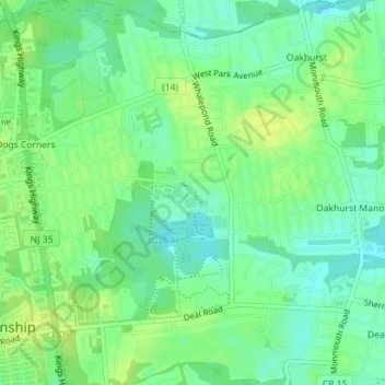
Name: Oakhurst topographic map, elevation, terrain.

Location: Oakhurst, Ocean Township, Monmouth County, New Jersey, 07755, United States (40.25183 -74.04201 40.27097 -74.01119)

Average elevation: 49 ft

Minimum elevation: 20 ft

Maximum elevation: 75 ft

Monmouth County trails, hiking, mountain biking, running and outdoor activities

Gear up for your next adventure:

📡Handheld GPS Device - Reliable handheld GPS for outdoor navigation
🪶Trail Camera - Capture wildlife on your hikes
📻Weather Alert Radios - Stay informed of storm risks while off-the-grid
🪶Compact Camp Shovel - Folding shovel for campsite tasks
🧯Emergency Survival Kit - All‑in‑one survival essentials for the backcountry

As an Amazon Associate, this site earns from qualifying purchases at no extra cost to you.