Geolocate

Coderuto topographic map

Click on the map to display elevation.

About this map

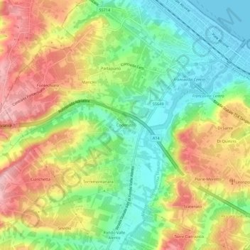
Name: Coderuto topographic map, elevation, terrain.

Location: Coderuto, Torrevecchia Teatina, Chieti, Abruzzo, 66023, Italy (42.39441 14.23701 42.43441 14.27701)

Average elevation: 253 ft

Minimum elevation: -13 ft

Maximum elevation: 561 ft

Gear up for your next adventure:

🧣Merino Neck Gaiters - Multi-functional headwear for wind and sun protection
🪶Compact Camp Shovel - Folding shovel for campsite tasks
🧭Orienteering Set - Complete compass and map reading kit
📶Vehicle Signal Boosters - Improve reception in rural areas while driving to trailheads
🛏️Cold Weather Sleeping Bag - Warm sleeping bag for cold conditions

As an Amazon Associate, this site earns from qualifying purchases at no extra cost to you.