
扯旗山 Victoria Peak topographic map
Interactive map
Click on the map to display elevation.
About this map
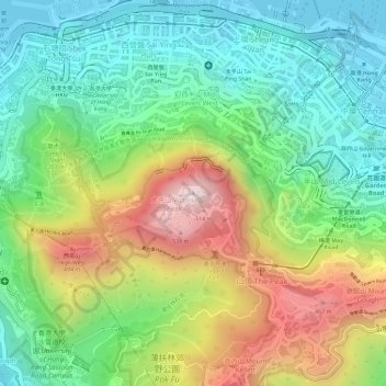
Name: 扯旗山 Victoria Peak topographic map, elevation, terrain.
Location: 扯旗山 Victoria Peak, Hong Kong Island, Hongkong, China (22.27599 114.14541 22.27609 114.14551)
Average elevation: 686 ft
Minimum elevation: -7 ft
Maximum elevation: 1,752 ft
Der Victoria Peak (chinesisch 太平山, Pinyin Tàipíng Shān, Jyutping Taai3ping4 Saan1 – „Friedensberg“) mit 552 Metern Höhe ist der bekannteste Berg Hongkongs. Auf Hong Kong Island gelegen, ist er zugleich die höchste Erhebung dieser Insel, wird jedoch vom 958 Meter hohen, in den New Territories gelegenen Tai Mo Shan deutlich überragt. Sein chinesischer Name Tai Ping Shan bedeutet „Berg des großen Friedens“. Der Gipfel bietet einen weiten Blick über Kowloon und große Teile der Insel Hongkong.
Other topographic maps
Click on a map to view its topography, its elevation and its terrain.
Victoria Peak Lookout (over the Victoria Harbour)
China > Hongkong > Hong Kong Island
Victoria Peak Lookout (over the Victoria Harbour), 盧吉道 Lugard Road, 太平山 Victoria Peak, 山頂 The Peak, 中西區 Central and Western District, Hong Kong Island, Hongkong, China
Average elevation: 627 ft
Southern District
China > Hongkong > Hong Kong Island
Southern District, Hong Kong Island, Hongkong, China
Average elevation: 118 ft
中區 Central District
China > Hongkong > Hong Kong Island
中區 Central District, Hong Kong Island, Hongkong, China
Average elevation: 374 ft