
中區 Central District topographic map
Interactive map
Click on the map to display elevation.
About this map
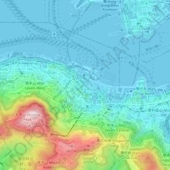
Name: 中區 Central District topographic map, elevation, terrain.
Location: 中區 Central District, Hong Kong Island, Hongkong, China (22.26274 114.13871 22.30274 114.17871)
Average elevation: 374 ft
Minimum elevation: -13 ft
Maximum elevation: 1,752 ft
Other topographic maps
Click on a map to view its topography, its elevation and its terrain.
扯旗山 Victoria Peak
China > Hongkong > Hong Kong Island
扯旗山 Victoria Peak, Hong Kong Island, Hongkong, China
Average elevation: 686 ft
Victoria Peak Lookout (over the Victoria Harbour)
China > Hongkong > Hong Kong Island
Victoria Peak Lookout (over the Victoria Harbour), 盧吉道 Lugard Road, 太平山 Victoria Peak, 山頂 The Peak, 中西區 Central and Western District, Hong Kong Island, Hongkong, China
Average elevation: 627 ft
Southern District
China > Hongkong > Hong Kong Island
Southern District, Hong Kong Island, Hongkong, China
Average elevation: 118 ft