
Make a donation
Gear up for your next adventure:
As an Amazon Associate, this site earns from qualifying purchases at no extra cost to you.
Criuleni District topographic map
Click on the map to display elevation.
Make a donation
Gear up for your next adventure:
As an Amazon Associate, this site earns from qualifying purchases at no extra cost to you.
Criuleni District
Criuleni District is located in the central part of Moldova. Does the neighborhood: in the north Orhei District, Dubăsari District in the east, south Anenii Noi District, in western Municipality of Chișinău, and Strășeni District. District is located within the eastern extremity of Central Moldavian Plateau, and northern part of Lower Nistru Plains. The landscape is characterized by intercalation of deep valleys and wide. On steep slopes erosion occurs, and landslides. Horizontal dismantling of relief averaged 1.0-1.5 km / km2. Vertical dismemberment of the territory makes up an average of 120–130 m. The northern part of Lower Nistru Plain is characterized by absolute altitudes of 100–200 m by the presence of a flat and low relief fragmented. In some places, meet some narrow valleys, not too deep, valleys, whose depth does not exceed 20–30 m. Erosion occurs weak. Ravines have a limited spread, but the flat slope erosion processes are developed. District has deposits minerals: limestone, sand, gravel and clay. In the district are 10 mines acquisition of limestone blocks, and 7 operating sand quarries gravel and crushed stone. In places where limestone rocks appear on the surface karst processes develop. Absolute altitude between 265 m swing territory, and 40 m in the meadow Raut
Make a donation
Gear up for your next adventure:
As an Amazon Associate, this site earns from qualifying purchases at no extra cost to you.
About this map
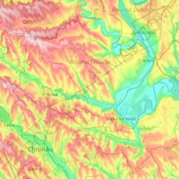
Name: Criuleni District topographic map, elevation, terrain.
Location: Criuleni District, Moldova (46.96947 28.74794 47.32716 29.29650)
Average elevation: 400 ft
Minimum elevation: 30 ft
Maximum elevation: 919 ft
Make a donation
Gear up for your next adventure:
As an Amazon Associate, this site earns from qualifying purchases at no extra cost to you.
Other topographic maps
Click on a map to view its topography, its elevation and its terrain.
Make a donation
Gear up for your next adventure:
As an Amazon Associate, this site earns from qualifying purchases at no extra cost to you.
Make a donation
Gear up for your next adventure:
As an Amazon Associate, this site earns from qualifying purchases at no extra cost to you.
Make a donation
Gear up for your next adventure:
As an Amazon Associate, this site earns from qualifying purchases at no extra cost to you.
Drochia
Drochia (Romanian pronunciation: ) is a city in the northern part of Moldova. It is the administrative center of the eponymous district. The city is located 174.4 km (108.4 mi) north of the national capital, Chişinău, and 67 km (42 mi) north-east of the Romanian city of Iaşi. The average elevation of…
Average elevation: 538 ft
Make a donation
Gear up for your next adventure:
As an Amazon Associate, this site earns from qualifying purchases at no extra cost to you.
Make a donation
Gear up for your next adventure:
As an Amazon Associate, this site earns from qualifying purchases at no extra cost to you.
Make a donation
Gear up for your next adventure:
As an Amazon Associate, this site earns from qualifying purchases at no extra cost to you.