
Make a donation
Gear up for your next adventure:
As an Amazon Associate, this site earns from qualifying purchases at no extra cost to you.
Mühlheim topographic map
Click on the map to display elevation.
Make a donation
Gear up for your next adventure:
As an Amazon Associate, this site earns from qualifying purchases at no extra cost to you.
Mühlheim
Die Stadt liegt zwischen Schwarzwald und Schwäbischer Alb rund 60 Kilometer südwestlich von Stuttgart auf einer Höhe von 410 bis 675 m ü. NHN. Sulz hat mit einer Größe von 87,60 km² das größte Gemeindegebiet im Landkreis Rottweil.
Make a donation
Gear up for your next adventure:
As an Amazon Associate, this site earns from qualifying purchases at no extra cost to you.
About this map
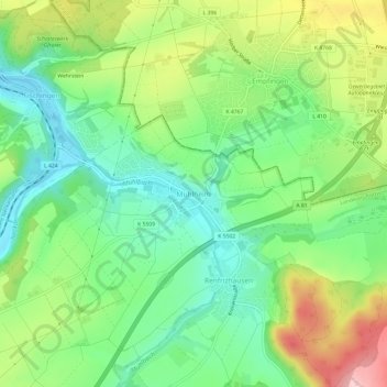
Name: Mühlheim topographic map, elevation, terrain.
Average elevation: 1,604 ft
Minimum elevation: 1,348 ft
Maximum elevation: 2,037 ft
Make a donation
Gear up for your next adventure:
As an Amazon Associate, this site earns from qualifying purchases at no extra cost to you.
Other topographic maps
Click on a map to view its topography, its elevation and its terrain.
72172
Deutschland > Baden-Württemberg > Landkreis Rottweil > Sulz am Neckar
Average elevation: 1,814 ft
Hopfau
Deutschland > Baden-Württemberg > Landkreis Rottweil > Sulz am Neckar
Average elevation: 1,860 ft
Bergfelden
Deutschland > Baden-Württemberg > Landkreis Rottweil > Sulz am Neckar
Bergfelden liegt knapp fünf Kilometer östlich der Stadt Sulz am Neckar, im oberen Mühlbachtal am Fuße des Dickebergs. Der Ort liegt auf einer Höhe von 490 m ü. NN und hat ca. 1700 Einwohner (Stand 2015).
Average elevation: 1,732 ft
Holzhausen
Deutschland > Baden-Württemberg > Landkreis Rottweil > Sulz am Neckar
Average elevation: 1,644 ft
Make a donation
Gear up for your next adventure:
As an Amazon Associate, this site earns from qualifying purchases at no extra cost to you.
Dürrenmettstetten
Deutschland > Baden-Württemberg > Landkreis Rottweil > Sulz am Neckar
Average elevation: 2,057 ft
Hopfau
Deutschland > Baden-Württemberg > Landkreis Rottweil > Sulz am Neckar
Average elevation: 1,860 ft
Hopfau
Deutschland > Baden-Württemberg > Landkreis Rottweil > Sulz am Neckar
Average elevation: 1,860 ft