
Make a donation
Gear up for your next adventure:
As an Amazon Associate, this site earns from qualifying purchases at no extra cost to you.
Isle Royale topographic map
Click on the map to display elevation.
Make a donation
Gear up for your next adventure:
As an Amazon Associate, this site earns from qualifying purchases at no extra cost to you.
Isle Royale
According to the Köppen climate classification system, Isle Royale National Park has a mild summer Humid continental climate (Dfb). According to the United States Department of Agriculture, the Plant Hardiness zone is 4b at 1178 ft (359 m) elevation with an average annual extreme minimum temperature of -24.2 °F (-31.2 °C).
Make a donation
Gear up for your next adventure:
As an Amazon Associate, this site earns from qualifying purchases at no extra cost to you.
About this map
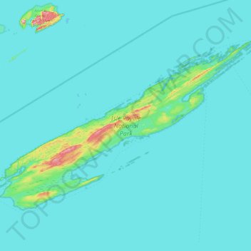
Name: Isle Royale topographic map, elevation, terrain.
Location: Isle Royale, Keweenaw County, Michigan, United States (47.82376 -89.23555 48.19102 -88.42232)
Average elevation: 623 ft
Minimum elevation: 577 ft
Maximum elevation: 1,453 ft
Keweenaw County trails, hiking, mountain biking, running and outdoor activities
Make a donation
Gear up for your next adventure:
As an Amazon Associate, this site earns from qualifying purchases at no extra cost to you.
Other topographic maps
Click on a map to view its topography, its elevation and its terrain.
Make a donation
Gear up for your next adventure:
As an Amazon Associate, this site earns from qualifying purchases at no extra cost to you.
Montreal River
United States > Michigan > Keweenaw County > Nepco Camp Number 7
Average elevation: 1,132 ft