Geolocate

Port Hudson topographic map

Click on the map to display elevation.

About this map

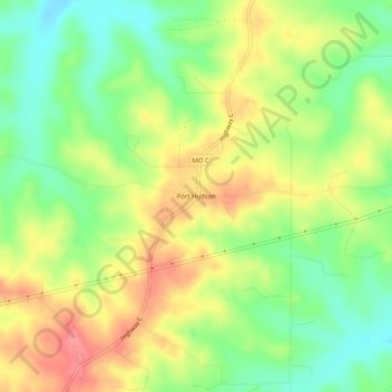
Name: Port Hudson topographic map, elevation, terrain.

Location: Port Hudson, Franklin County, Missouri, United States (38.43394 -91.27404 38.47394 -91.23404)

Average elevation: 794 ft

Minimum elevation: 666 ft

Maximum elevation: 938 ft

Franklin County trails, hiking, mountain biking, running and outdoor activities

Other topographic maps

Click on a map to view its topography, its elevation and its terrain.

Washington

United States > Missouri > Franklin County

Average elevation: 551 ft

Villa Ridge

United States > Missouri > Franklin County

Average elevation: 653 ft

Miramiguoa Park

United States > Missouri > Franklin County

Average elevation: 676 ft

Leslie

United States > Missouri > Franklin County

Average elevation: 771 ft

Berger

United States > Missouri > Franklin County

Average elevation: 561 ft

St. Clair

United States > Missouri > Franklin County

Average elevation: 696 ft

Gray Summit

United States > Missouri > Franklin County

Average elevation: 630 ft

Parkway

United States > Missouri > Franklin County

Average elevation: 699 ft

Gear up for your next adventure:

🧤Hiking Gloves - Protective gloves for rugged trails
🛡️Insect Repellent - Protection against bugs during outdoor activities
🧯Portable Fire Pit - Compact fire pit for camping spots
☀️Outdoor Sunscreen - High protection sunscreen for outdoor activities
🖼️Topo Map Wall Art - Decorative topographic prints of famous peaks and regions

As an Amazon Associate, this site earns from qualifying purchases at no extra cost to you.