
Make a donation
Gear up for your next adventure:
As an Amazon Associate, this site earns from qualifying purchases at no extra cost to you.
Südufer topographic map
Click on the map to display elevation.
Make a donation
Gear up for your next adventure:
As an Amazon Associate, this site earns from qualifying purchases at no extra cost to you.
About this map
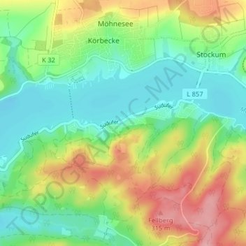
Name: Südufer topographic map, elevation, terrain.
Average elevation: 830 ft
Minimum elevation: 682 ft
Maximum elevation: 1,073 ft
Make a donation
Gear up for your next adventure:
As an Amazon Associate, this site earns from qualifying purchases at no extra cost to you.
Other topographic maps
Click on a map to view its topography, its elevation and its terrain.
Stockum
Deutschland > Nordrhein-Westfalen > Kreis Soest > Möhnesee
Stockum befindet sich etwa 2 km nordöstlich von Körbecke, dem Zentralort der Gemeinde. Der Ort liegt am Nordufer des Möhnesees auf halber Höhe des Haarstranges.
Average elevation: 892 ft
Möhnesee
Deutschland > Nordrhein-Westfalen > Kreis Soest > Möhnesee
Der Bau der Talsperre beinhaltete von Anfang an auch ein Wasserkraftwerk, um mit den Einnahmen aus dem Stromverkauf die Finanzierung zu unterstützen. Das Kraftwerk sollte aber vorwiegend nach wasserwirtschaftlichen Belangen betrieben werden, sodass aufgrund der schwankenden Wasserabgaben und der wechselnden…
Average elevation: 823 ft
Make a donation
Gear up for your next adventure:
As an Amazon Associate, this site earns from qualifying purchases at no extra cost to you.