Geolocate

Beverstedt topographic map

Click on the map to display elevation.

About this map

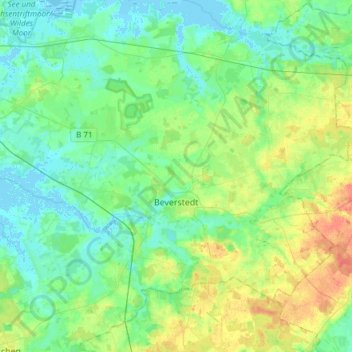
Name: Beverstedt topographic map, elevation, terrain.

Location: Beverstedt, Landkreis Cuxhaven, Lower Saxony, 27616, Germany (53.37253 8.67047 53.52149 8.97320)

Average elevation: 39 ft

Minimum elevation: -13 ft

Maximum elevation: 131 ft

Gear up for your next adventure:

🚪Portable Camp Chair - Foldable chair for comfort at camp
🪑Portable Camp Table - Compact table for campsite meals
🛠️Backpacking Tool Kit - Essential toolkit for outdoor repairs
📡Handheld GPS Device - Reliable handheld GPS for outdoor navigation
🩹Survival Bandages - High‑quality bandages for emergencies

As an Amazon Associate, this site earns from qualifying purchases at no extra cost to you.