Geolocate

Read topographic map

Click on the map to display elevation.

About this map

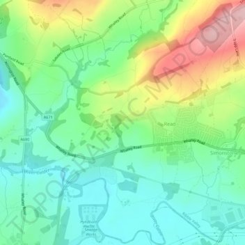
Name: Read topographic map, elevation, terrain.

Location: Read, Ribble Valley, Lancashire, England, United Kingdom (53.79287 -2.38712 53.82509 -2.33235)

Average elevation: 374 ft

Minimum elevation: 164 ft

Maximum elevation: 794 ft

Gear up for your next adventure:

🧭Compass with Lanyard - Easy‑carry compass for navigation
🥇GPS Hiking Watch - Multi‑sport GPS watch with navigation and trail tracking
🪶Multi‑Purpose Knife - Useful blade for camp and trail
🪓Survival Multi‑Tool - Versatile tool for camp and trail tasks
Backpacking Tent - Lightweight and durable tent for multi‑day hikes

As an Amazon Associate, this site earns from qualifying purchases at no extra cost to you.