
Make a donation
Gear up for your next adventure:
As an Amazon Associate, this site earns from qualifying purchases at no extra cost to you.
Checotah topographic map
Click on the map to display elevation.
Make a donation
Gear up for your next adventure:
As an Amazon Associate, this site earns from qualifying purchases at no extra cost to you.
Checotah
Checotah is located at an elevation of 652 feet (199 m) at the intersection of I-40 and U.S. Route 69. Nearby is Eufaula Lake, the largest-capacity lake wholly within the state of Oklahoma.
Make a donation
Gear up for your next adventure:
As an Amazon Associate, this site earns from qualifying purchases at no extra cost to you.
About this map
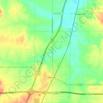
Name: Checotah topographic map, elevation, terrain.
Location: Checotah, McIntosh County, Oklahoma, 74426, United States (35.44943 -95.54899 35.53302 -95.50439)
Average elevation: 620 ft
Minimum elevation: 551 ft
Maximum elevation: 709 ft
Make a donation
Gear up for your next adventure:
As an Amazon Associate, this site earns from qualifying purchases at no extra cost to you.
Other topographic maps
Click on a map to view its topography, its elevation and its terrain.
Honey Springs Battlefield
United States > Oklahoma > McIntosh County > Rentiesville
Average elevation: 607 ft