
Morang topographic map
Interactive map
Click on the map to display elevation.
About this map
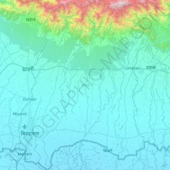
Name: Morang topographic map, elevation, terrain.
Location: Morang, Province #1, Nepal (26.34776 87.23847 26.87340 87.69077)
Average elevation: 860 ft
Minimum elevation: 190 ft
Maximum elevation: 7,677 ft
Morang District (Nepali: मोरङ जिल्ला listen (help·info)) is located in Province No. 1 in eastern Nepal. It is an Outer Terai district. It borders with Bihar, India to the South, Jhapa to the East, Dhankuta and Panchthar to the North, and Sunsari to the west. Morang has one metropolitan city (Biratnagar), eight municipalities and eight rural municipalities. The total area of Morang is 1,855 km2 (716 sq mi). The lowest elevation point is 60 meters and the highest is 2410 meters above sea level. The headquarters of Morang is connected by Koshi National Highway to the east–west Mahendra National Highway at Itahari, Sunsari, and Morang is also connected to the Hill parts of the eastern region of Nepal. Morang is the core industrial sector for the eastern region of Nepal.
Other topographic maps
Click on a map to view its topography, its elevation and its terrain.
Mount Everest
Nepal > Eastern Development Region > Khumjung
Mount Everest, Khumjung, Solukhumbu, Sagarmatha, Eastern Development Region, Nepal
Average elevation: 25,725 ft
Makalu
Nepal > Eastern Development Region > Makalu
Makalu, Sankhuwasabha, Koshi, Eastern Development Region, Nepal
Average elevation: 13,346 ft
Mera Peak
Nepal > Eastern Development Region > Bung
Mera Peak, Bung, Solukhumbu, Sagarmatha, Eastern Development Region, Nepal
Average elevation: 18,730 ft
Lelep
Nepal > Eastern Development Region > Lelep
Lelep, Taplejung, Mechi, Eastern Development Region, Nepal
Average elevation: 14,377 ft
Daulatpur
Nepal > Eastern Development Region > Daulatpur
Daulatpur, Surunga, Saptari, Sagarmatha, Eastern Development Region, Nepal
Average elevation: 400 ft
Narayanganj
Nepal > Eastern Development Region > Narayanganj
Narayanganj, Mechinagar, Jhapa, Eastern Development Region, Nepal
Average elevation: 925 ft
Lhotse Shar
Nepal > Eastern Development Region > Khumjung
Lhotse Shar, Khumjung, Solukhumbu, Sagarmatha, Eastern Development Region, Nepal
Average elevation: 23,468 ft
Durgapur
Nepal > Eastern Development Region > Durgapur
Durgapur, Siraha, Sagarmatha, Eastern Development Region, Nepal
Average elevation: 361 ft
Eastern Development Region
Nepal > Eastern Development Region
Eastern Development Region, Nepal
Average elevation: 7,283 ft
Boya
Nepal > Eastern Development Region > Boya
Boya, Bhojpur, Koshi, Eastern Development Region, Nepal
Average elevation: 4,751 ft
Mahalangur Himal
Nepal > Eastern Development Region > Makalu
Mahalangur Himal, Makalu, Sankhuwasabha, Koshi, Eastern Development Region, Nepal
Average elevation: 15,404 ft
Ngozumpa Glacier
Nepal > Eastern Development Region > Khumjung > Khumjung
Ngozumpa Glacier, Khumjung, Solukhumbu, Sagarmatha, Eastern Development Region, Nepal
Average elevation: 18,478 ft
Island Peak
Nepal > Eastern Development Region > Khumjung
Island Peak, Khumjung, Khumbupasanglahmu, Solukhumbu, Province #1, Nepal
Average elevation: 17,917 ft