
Gemeinde Dürnstein topographic map
Interactive map
Click on the map to display elevation.
About this map
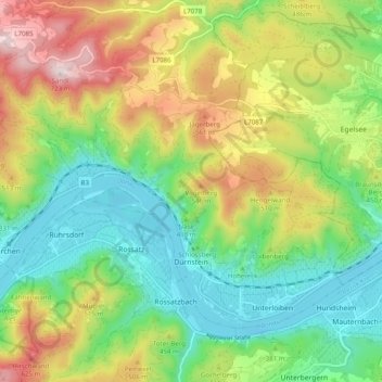
Name: Gemeinde Dürnstein topographic map, elevation, terrain.
Location: Gemeinde Dürnstein, Bezirk Krems, Lower Austria, 3601, Austria (48.38399 15.46369 48.43085 15.56227)
Average elevation: 1,253 ft
Minimum elevation: 614 ft
Maximum elevation: 2,316 ft
Other topographic maps
Click on a map to view its topography, its elevation and its terrain.
Rastenfeld
Austria > Lower Austria > Bezirk Krems > Gemeinde Rastenfeld
Rastenfeld, Gemeinde Rastenfeld, Bezirk Krems, Lower Austria, 3532, Austria
Average elevation: 1,837 ft
Gemeinde Rastenfeld
Austria > Lower Austria > Bezirk Krems
Gemeinde Rastenfeld, Bezirk Krems, Lower Austria, 3532, Austria
Average elevation: 1,854 ft
Klein-Wien
Austria > Lower Austria > Bezirk Krems > Gemeinde Furth bei Göttweig
Klein-Wien, Gemeinde Furth bei Göttweig, Bezirk Krems, Lower Austria, 3511, Austria
Average elevation: 1,010 ft