
Make a donation
Gear up for your next adventure:
As an Amazon Associate, this site earns from qualifying purchases at no extra cost to you.
New Plymouth topographic map
Click on the map to display elevation.
Make a donation
Gear up for your next adventure:
As an Amazon Associate, this site earns from qualifying purchases at no extra cost to you.
New Plymouth
New Plymouth is located at 43°58′14″N 116°49′14″W / 43.97056°N 116.82056°W / 43.97056; -116.82056 (43.970689, -116.820449), at an elevation of 2,260 feet (689 m) above sea level.
Make a donation
Gear up for your next adventure:
As an Amazon Associate, this site earns from qualifying purchases at no extra cost to you.
About this map
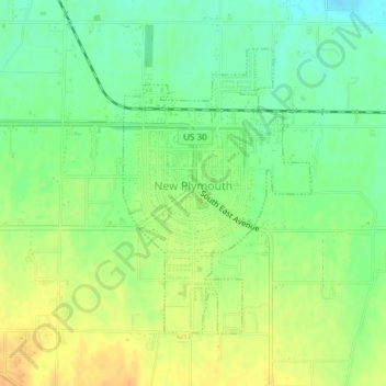
Name: New Plymouth topographic map, elevation, terrain.
Location: New Plymouth, Payette County, Idaho, 83655, United States (43.95968 -116.82670 43.97989 -116.80841)
Average elevation: 2,260 ft
Minimum elevation: 2,208 ft
Maximum elevation: 2,316 ft
Payette County trails, hiking, mountain biking, running and outdoor activities
Make a donation
Gear up for your next adventure:
As an Amazon Associate, this site earns from qualifying purchases at no extra cost to you.