
Thank you for supporting this site ❤️
Make a donation
Make a donation
Gear up for your next adventure:
As an Amazon Associate, this site earns from qualifying purchases at no extra cost to you.
Azêvo topographic map
Click on the map to display elevation.
Thank you for supporting this site ❤️
Make a donation
Make a donation
Gear up for your next adventure:
As an Amazon Associate, this site earns from qualifying purchases at no extra cost to you.
About this map
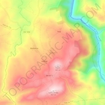
Name: Azêvo topographic map, elevation, terrain.
Location: Azêvo, Vale do Côa, Pinhel, Guarda, Portugal (40.83096 -7.15132 40.87096 -7.11132)
Average elevation: 1,673 ft
Minimum elevation: 938 ft
Maximum elevation: 2,178 ft
Thank you for supporting this site ❤️
Make a donation
Make a donation
Gear up for your next adventure:
As an Amazon Associate, this site earns from qualifying purchases at no extra cost to you.
Other topographic maps
Click on a map to view its topography, its elevation and its terrain.
Área Protegida Privada Faia Brava
Portugal > Guarda > Vale do Côa > Cidadelhe
Average elevation: 1,365 ft