
Make a donation
Gear up for your next adventure:
As an Amazon Associate, this site earns from qualifying purchases at no extra cost to you.
Vatican Hill topographic map
Click on the map to display elevation.
Make a donation
Gear up for your next adventure:
As an Amazon Associate, this site earns from qualifying purchases at no extra cost to you.
About this map
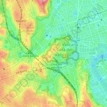
Name: Vatican Hill topographic map, elevation, terrain.
Location: Vatican Hill, 00120, Vatican City (41.90273 12.44985 41.90283 12.44995)
Average elevation: 167 ft
Minimum elevation: 30 ft
Maximum elevation: 358 ft
Make a donation
Gear up for your next adventure:
As an Amazon Associate, this site earns from qualifying purchases at no extra cost to you.
Other topographic maps
Click on a map to view its topography, its elevation and its terrain.
Vatican City
Vatican City's climate is the same as Rome's: a temperate, Mediterranean climate Csa with mild, rainy winters from October to mid-May and hot, dry summers from May to September. Some minor local features, principally mists and dews, are caused by the anomalous bulk of St Peter's Basilica, the elevation, the…
Average elevation: 154 ft