
Hurlingham topographic map
Click on the map to display elevation.
About this map
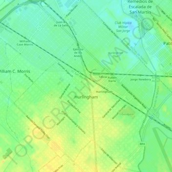
Name: Hurlingham topographic map, elevation, terrain.
Location: Hurlingham, Partido de Hurlingham, Buenos Aires, Argentina (-34.61249 -58.66017 -34.56883 -58.61641)
Average elevation: 46 ft
Minimum elevation: 7 ft
Maximum elevation: 89 ft
Other topographic maps
Click on a map to view its topography, its elevation and its terrain.
José León Suárez
Argentina > Buenos Aires > José León Suárez > José León Suárez
Average elevation: 56 ft
Ingeniero Maschwitz
Argentina > Buenos Aires > Ingeniero Maschwitz > Ingeniero Maschwitz
Average elevation: 33 ft