
Make a donation
Gear up for your next adventure:
As an Amazon Associate, this site earns from qualifying purchases at no extra cost to you.
Cotati topographic map
Click on the map to display elevation.
Make a donation
Gear up for your next adventure:
As an Amazon Associate, this site earns from qualifying purchases at no extra cost to you.
About this map
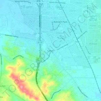
Name: Cotati topographic map, elevation, terrain.
Location: Cotati, Sonoma County, California, 94931, United States (38.31499 -122.72953 38.34313 -122.68777)
Average elevation: 138 ft
Minimum elevation: 85 ft
Maximum elevation: 420 ft
Make a donation
Gear up for your next adventure:
As an Amazon Associate, this site earns from qualifying purchases at no extra cost to you.
Other topographic maps
Click on a map to view its topography, its elevation and its terrain.
Fort Ross
United States > California > Sonoma County > Fort Ross
The Native Alaskan Village site was the subject of an investigation into its spatial organization, seeing “topographic mapping of surface features, systematic surface collection and generation of artifact distribution maps, and geophysical investigations involving both magnetometer and soil resistance…
Average elevation: 223 ft