
Make a donation
Gear up for your next adventure:
As an Amazon Associate, this site earns from qualifying purchases at no extra cost to you.
Gemeinde Lech topographic map
Click on the map to display elevation.
Make a donation
Gear up for your next adventure:
As an Amazon Associate, this site earns from qualifying purchases at no extra cost to you.
Gemeinde Lech
The altitude of 1444 m for the village refers to the location of the old church on a hill. 14.1% of the municipal area is forested, 58% of the area is Alpine. Geographically and historically, Lech belongs to the Hochtannberg region, formerly Tannberg, but in terms of tourism the municipality is part of the Arlberg region. Lech belongs to the district of Bludenz and also to the judicial district of Bludenz, but unlike its southern neighboring communities of Klösterle and Dalaas, which also belong to the district of Bludenz, it is not located in the Klostertal, but in the Arlberg massif to the northeast of it.
Make a donation
Gear up for your next adventure:
As an Amazon Associate, this site earns from qualifying purchases at no extra cost to you.
About this map
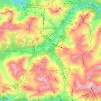
Name: Gemeinde Lech topographic map, elevation, terrain.
Location: Gemeinde Lech, Bezirk Bludenz, Vorarlberg, Austria (47.14803 10.03213 47.25166 10.21375)
Average elevation: 6,388 ft
Minimum elevation: 3,819 ft
Maximum elevation: 9,127 ft
Make a donation
Gear up for your next adventure:
As an Amazon Associate, this site earns from qualifying purchases at no extra cost to you.
Other topographic maps
Click on a map to view its topography, its elevation and its terrain.
Stuben
Austria > Vorarlberg > Bezirk Bludenz
Stuben am Arlberg is a winter sports resort in the town of Klösterle in the westernmost Austrian province of Vorarlberg. It is located at an altitude of 1,410 meters and had 90 inhabitants (as of 1 January 2019).
Average elevation: 6,138 ft
Außerziggam
Austria > Vorarlberg > Bezirk Bludenz > Gemeinde Sankt Gallenkirch > Sankt Gallenkirch > Außerziggam
Average elevation: 3,953 ft