
Make a donation
Gear up for your next adventure:
As an Amazon Associate, this site earns from qualifying purchases at no extra cost to you.
Göttingen topographic map
Click on the map to display elevation.
Make a donation
Gear up for your next adventure:
As an Amazon Associate, this site earns from qualifying purchases at no extra cost to you.
About this map
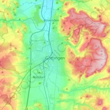
Name: Göttingen topographic map, elevation, terrain.
Location: Göttingen, Landkreis Göttingen, Lower Saxony, Germany (51.48302 9.80014 51.59082 10.05361)
Average elevation: 784 ft
Minimum elevation: 423 ft
Maximum elevation: 1,434 ft
Make a donation
Gear up for your next adventure:
As an Amazon Associate, this site earns from qualifying purchases at no extra cost to you.
Other topographic maps
Click on a map to view its topography, its elevation and its terrain.
Kamschlacken
Germany > Lower Saxony > Landkreis Göttingen > Osterode am Harz > Riefensbeek-Kamschlacken
Average elevation: 1,683 ft
Make a donation
Gear up for your next adventure:
As an Amazon Associate, this site earns from qualifying purchases at no extra cost to you.
Zoll
Germany > Lower Saxony > Landkreis Göttingen > Bad Lauterberg im Harz > Barbis
Average elevation: 1,033 ft
Make a donation
Gear up for your next adventure:
As an Amazon Associate, this site earns from qualifying purchases at no extra cost to you.