Geolocate

Sieber topographic map

Click on the map to display elevation.

About this map

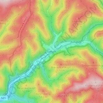
Name: Sieber topographic map, elevation, terrain.

Location: Sieber, Herzberg, Landkreis Göttingen, Lower Saxony, Germany (51.67830 10.40502 51.71830 10.44502)

Average elevation: 1,650 ft

Minimum elevation: 991 ft

Maximum elevation: 2,293 ft

Gear up for your next adventure:

🪶Survival Guide Book - Expert advice for emergency preparedness
🧢Sun Protection Hats - Wide-brimmed and UPF-rated hats for high-altitude sun safety
🎒Trail Energy Bars - High‑calorie bars for hiking energy
🚗GPS Dash Cams - Record your scenic drives through mountain passes and canyons
🏥Hiking First Aid Kits - Comprehensive medical kits for remote trail injuries

As an Amazon Associate, this site earns from qualifying purchases at no extra cost to you.