Geolocate

Michigan City topographic map

Click on the map to display elevation.

About this map

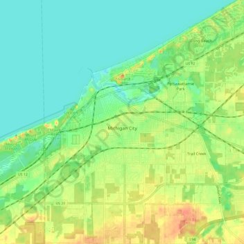
Name: Michigan City topographic map, elevation, terrain.

Location: Michigan City, LaPorte County, Indiana, United States (41.66581 -86.93268 41.75345 -86.81609)

Average elevation: 617 ft

Minimum elevation: 564 ft

Maximum elevation: 696 ft

LaPorte County trails, hiking, mountain biking, running and outdoor activities

Other topographic maps

Click on a map to view its topography, its elevation and its terrain.

Fish Lake

United States > Indiana > LaPorte County

Average elevation: 705 ft

Holmesville

United States > Indiana > LaPorte County

Average elevation: 787 ft

Springville

United States > Indiana > LaPorte County

Average elevation: 751 ft

Otis

United States > Indiana > LaPorte County

Average elevation: 748 ft

Gear up for your next adventure:

📷Action Camera - Capture your outdoor adventures in HD
🗺️NatGeo Topo Maps - High-quality waterproof printed topographic maps of US Parks
🧤Tactile Hiking Gloves - Keep hands warm while operating GPS and smartphone screens
🪄Magnetic Compass - Accurate compass for navigation
🚗GPS Dash Cams - Record your scenic drives through mountain passes and canyons

As an Amazon Associate, this site earns from qualifying purchases at no extra cost to you.