Geolocate

Davao City topographic map

Click on the map to display elevation.

About this map

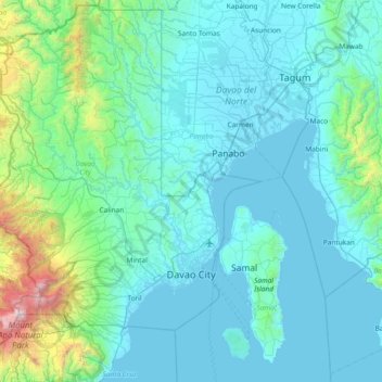
Name: Davao City topographic map, elevation, terrain.

Location: Davao City, Davao Occidental, Davao Region, Philippines (6.85577 125.20809 7.59655 125.69093)

Average elevation: 994 ft

Minimum elevation: 0 ft

Maximum elevation: 9,583 ft

Gear up for your next adventure:

📚USA Hiking Guide Books - Top trail guides and map books
🛏️Cold Weather Sleeping Bag - Warm sleeping bag for cold conditions
🧤Hiking Gloves - Protective gloves for rugged trails
👟Trail Running Shoes - Lightweight shoes for trail runners
📶Vehicle Signal Boosters - Improve reception in rural areas while driving to trailheads

As an Amazon Associate, this site earns from qualifying purchases at no extra cost to you.