
Tirana topographic map
Click on the map to display elevation.
Tirana
Tirana is positioned in the central region of Albania, occupying the fertile Plain of Tirana, which is bordered by significant geographical features. To the east, the city is flanked by the Dajti Mountains, offering a dramatic backdrop with elevations reaching nearly 6,000 feet at Maja Mincekut. The south is characterized by rolling hills, including the Kërrabe, Sauk, and Vaqarr ranges. To the north, a valley descends towards the Adriatic Sea, influencing the local climate and ecology. The average elevation of Tirana itself is approximately 360 feet above sea level, contributing to a varied terrain that combines urban development with natural landscapes.
About this map
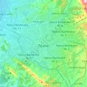
Name: Tirana topographic map, elevation, terrain.
Average elevation: 479 ft
Minimum elevation: 174 ft
Maximum elevation: 1,775 ft
Other topographic maps
Click on a map to view its topography, its elevation and its terrain.
Mullet
Albania > Central Albania > Tirana County
Mullet (Albanian definite form: Mulleti) is a village in Tirana County, Albania. At the 2015 local government reform it became part of the municipality Tirana. It lies at an elevation of 551 feet (167 m).
Average elevation: 682 ft
Shporesh (Priskë e Madhe)
Albania > Central Albania > Tirana County > Dajt > Priskë e Madhe
Average elevation: 1,873 ft
Bathore (Kamëz)
Albania > Central Albania > Tirana County > Kamëz Municipality
Average elevation: 226 ft
Lagjja e Re (Pezë-Helmësi)
Albania > Central Albania > Tirana County > Pezë > Pezë-Helmës
Average elevation: 427 ft
Prengaj (Babrruja)
Albania > Central Albania > Tirana County > Kamëz Municipality > Babrru Shpat
Average elevation: 499 ft
Mollasej (Farka e Vogël)
Albania > Central Albania > Tirana County > Farkë > Farkë e Vogël
Average elevation: 656 ft
Liqeni i Farkës
Albania > Central Albania > Tirana County > Farkë > Farkë e Vogël > Mollasej (Farka e Vogël)
Average elevation: 636 ft