
เกาะกูด topographic map
Interactive map
Click on the map to display elevation.
About this map
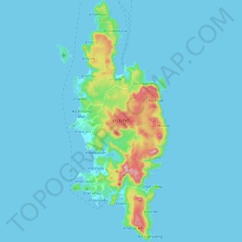
Name: เกาะกูด topographic map, elevation, terrain.
Location: เกาะกูด, จังหวัดตราด, 23120, Thaïlande (11.56152 102.52397 11.76233 102.60888)
Average elevation: 82 ft
Minimum elevation: -3 ft
Maximum elevation: 978 ft
Other topographic maps
Click on a map to view its topography, its elevation and its terrain.
หาดคลองเจ้า
Thaïlande > จังหวัดตราด > หาดคลองเจ้า
หาดคลองเจ้า, จังหวัดตราด, 23120, Thaïlande
Average elevation: 135 ft