Geolocate

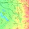
Siddington topographic map

Click on the map to display elevation.

About this map

Name: Siddington topographic map, elevation, terrain.

Location: Siddington, Cheshire East, England, United Kingdom (53.21937 -2.25986 53.26109 -2.19632)

Average elevation: 325 ft

Minimum elevation: 190 ft

Maximum elevation: 466 ft

Other topographic maps

Click on a map to view its topography, its elevation and its terrain.
Capesthorne

United Kingdom > England > Cheshire East > Siddington

Average elevation: 305 ft

Gear up for your next adventure:

🧭GPS Watch Accessories - Bands and chargers for GPS watches
🪄Magnetic Compass - Accurate compass for navigation
🌡️Handheld Weather Meters - Measure wind, temp, and pressure for safe mountain travel
🚁Photography Drones - Capture stunning aerial views of landforms and topography
🌲Outdoor Survival Books - Best books on survival skills

As an Amazon Associate, this site earns from qualifying purchases at no extra cost to you.