
Freixiel topographic map
Interactive map
Click on the map to display elevation.
About this map
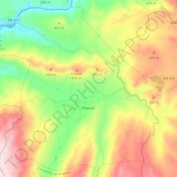
Name: Freixiel topographic map, elevation, terrain.
Location: Freixiel, Vila Flor, Distrito de Bragança, Portugal (41.29077 -7.29817 41.35383 -7.20819)
Average elevation: 1,529 ft
Minimum elevation: 568 ft
Maximum elevation: 2,592 ft
Other topographic maps
Click on a map to view its topography, its elevation and its terrain.
Roios
Portugal > Distrito de Bragança > Vila Flor
Roios, Vila Flor, Distrito de Bragança, Portugal
Average elevation: 1,614 ft
Assunção
Portugal > Distrito de Bragança > Vila Flor
Assunção, Vila Flor, Distrito de Bragança, 5370-135, Portugal
Average elevation: 1,837 ft
Lodões
Portugal > Distrito de Bragança > Vila Flor
Lodões, Vila Flor, Distrito de Bragança, Portugal
Average elevation: 840 ft
Seixo de Manhoses
Portugal > Distrito de Bragança > Vila Flor
Seixo de Manhoses, Vila Flor, Distrito de Bragança, Portugal
Average elevation: 1,877 ft
Folgares
Portugal > Distrito de Bragança > Vila Flor > Freixiel
Folgares, Freixiel, Vila Flor, Distrito de Bragança, Portugal
Average elevation: 1,778 ft