Geolocate

Pampa topographic map

Click on the map to display elevation.

About this map
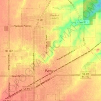
Name: Pampa topographic map, elevation, terrain.

Location: Pampa, Gray County, Texas, 79065, United States (35.51855 -100.99568 35.57719 -100.92760)

Average elevation: 3,225 ft

Minimum elevation: 3,110 ft

Maximum elevation: 3,261 ft

Gray County trails, hiking, mountain biking, running and outdoor activities

Other topographic maps

Click on a map to view its topography, its elevation and its terrain.
Alanreed

United States > Texas > Gray County

Average elevation: 2,966 ft

Gear up for your next adventure:

🔥Fast-Boil Camping Stoves - Efficient cooking systems for quick trail meals
📶Vehicle Signal Boosters - Improve reception in rural areas while driving to trailheads
🥘Titanium Cookware - Durable, featherlight pots and pans for backpacking
🗃️Trail First Aid Kit - Essential kit for outdoor injuries and emergencies
🧢Sun Protection Hats - Wide-brimmed and UPF-rated hats for high-altitude sun safety

As an Amazon Associate, this site earns from qualifying purchases at no extra cost to you.