Geolocate

Alanreed topographic map

Click on the map to display elevation.

About this map

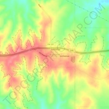
Name: Alanreed topographic map, elevation, terrain.

Location: Alanreed, Gray County, Texas, 79002, United States (35.19297 -100.75260 35.23297 -100.71260)

Average elevation: 2,966 ft

Minimum elevation: 2,835 ft

Maximum elevation: 3,071 ft

Gray County trails, hiking, mountain biking, running and outdoor activities

Other topographic maps

Click on a map to view its topography, its elevation and its terrain.

Pampa

United States > Texas > Gray County

Average elevation: 3,225 ft

Pampa

United States > Texas > Gray County

Average elevation: 3,225 ft

Gear up for your next adventure:

📷Action Camera - Capture your outdoor adventures in HD
🧷Carabiner Set - Durable clips for gear attachment
GPS Sports Watch - GPS watch for running, hiking and training
🛌Ultralight Sleeping Bags - Compact down bags for cold nights in the wilderness
🪶Camp Gear Gift Set - Perfect gift bundle for outdoor fans

As an Amazon Associate, this site earns from qualifying purchases at no extra cost to you.