Geolocate

Chennimalai topographic map

Click on the map to display elevation.

About this map
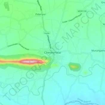
Name: Chennimalai topographic map, elevation, terrain.

Location: Chennimalai, Perundurai, Erode, Tamil Nadu, 638051, India (11.12432 77.56317 11.20432 77.64317)

Average elevation: 876 ft

Minimum elevation: 696 ft

Maximum elevation: 1,683 ft

Other topographic maps

Click on a map to view its topography, its elevation and its terrain.
Orathupalayam Dam

India > Tamil Nadu > Perundurai

Average elevation: 807 ft

Gear up for your next adventure:

🥾Hiking Shoes - Durable and comfortable shoes for trail hiking
🔪Outdoor Multitools - Essential survival tools for gear repair and field use
🗃️Trail First Aid Kit - Essential kit for outdoor injuries and emergencies
🎒Gear Packing Cubes - Organize your backpack efficiently
📦Dry Bags Set - Waterproof storage for electronics and clothes

As an Amazon Associate, this site earns from qualifying purchases at no extra cost to you.