
Northfield topographic map
Click on the map to display elevation.
Northfield
According to the United States Census Bureau, the city has an area of 8.61 square miles (22.30 km2); 8.56 square miles (22.17 km2) is land and 0.05 square miles (0.13 km2) is water. The peak elevation is about 912 feet.
About this map
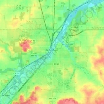
Name: Northfield topographic map, elevation, terrain.
Location: Northfield, Rice County, Minnesota, United States (44.42811 -93.22144 44.48590 -93.12889)
Average elevation: 978 ft
Minimum elevation: 879 ft
Maximum elevation: 1,112 ft
Rice County trails, hiking, mountain biking, running and outdoor activities
Other topographic maps
Click on a map to view its topography, its elevation and its terrain.