
Make a donation
Gear up for your next adventure:
As an Amazon Associate, this site earns from qualifying purchases at no extra cost to you.
Chía topographic map
Click on the map to display elevation.
Make a donation
Gear up for your next adventure:
As an Amazon Associate, this site earns from qualifying purchases at no extra cost to you.
Chía
El municipio de Chía está situado en el altiplano cundiboyacense (Cordillera Oriental de los Andes), a una altitud promedio de poco menos de 2600 m s. n. m. El casco urbano cuenta con un área de 17 km² y el área total del municipio es de aproximadamente 79 km².
Make a donation
Gear up for your next adventure:
As an Amazon Associate, this site earns from qualifying purchases at no extra cost to you.
About this map
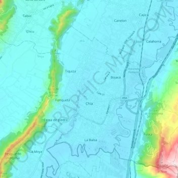
Name: Chía topographic map, elevation, terrain.
Location: Chía, Cundinamarca, Colombia (4.82102 -74.09442 4.91962 -73.98227)
Average elevation: 8,576 ft
Minimum elevation: 8,327 ft
Maximum elevation: 10,551 ft
Make a donation
Gear up for your next adventure:
As an Amazon Associate, this site earns from qualifying purchases at no extra cost to you.