Geolocate

Taconite topographic map

Click on the map to display elevation.

About this map
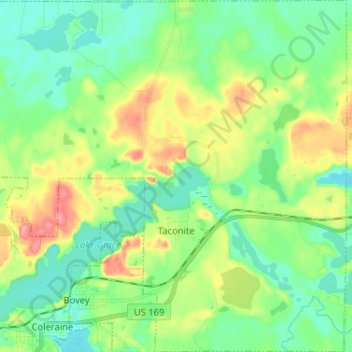
Name: Taconite topographic map, elevation, terrain.

Location: Taconite, Itasca County, Minnesota, United States (47.28241 -93.44804 47.37014 -93.31941)

Average elevation: 1,378 ft

Minimum elevation: 1,280 ft

Maximum elevation: 1,578 ft

Itasca County trails, hiking, mountain biking, running and outdoor activities

Other topographic maps

Click on a map to view its topography, its elevation and its terrain.
Togo

United States > Minnesota > Itasca County

Average elevation: 1,339 ft

Upper Twin Lakes

United States > Minnesota > Itasca County > Rosy

Average elevation: 1,342 ft

Gunny Sack Lake

United States > Minnesota > Itasca County

Average elevation: 1,375 ft

Gear up for your next adventure:

🧭Hiking Compass - Precision compass for reliable navigation in the wilderness
🛏️Cold Weather Sleeping Bag - Warm sleeping bag for cold conditions
🎒Trekking Poles - Sturdy poles for balance and stability on rough terrain
🧭Map Reading Tools - Tools and kits for map navigation
🥾Hiking Shoes - Durable and comfortable shoes for trail hiking

As an Amazon Associate, this site earns from qualifying purchases at no extra cost to you.